Property Record
1832 N Walkers Mill Rd, Griffin, GA 30223
NEARBY LISTINGS FOR SALE OR LEASE
Property Detail
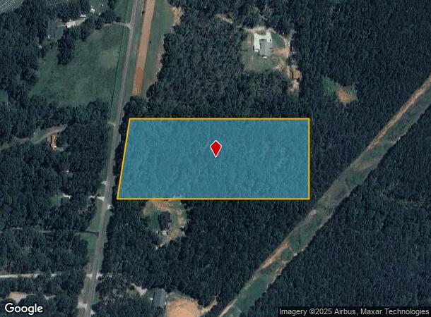
1832 N Walkers Mill Rd
Atlanta-Sandy Springs-Roswell, GA
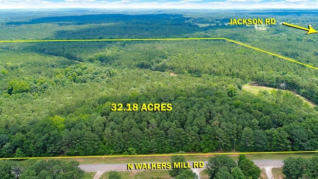
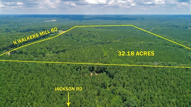
7.272AC N WALKERS MILL RD PB 26/689
204-01-010
Spalding
Privatepreserveopenspacevacantlandforestlandconservation
Georgia
X
1
13255C0095E
7.27 AC
2024
Spalding County
2024
Atlanta
160201
DEMOGRAPHICS near 1832 N Walkers Mill Rd
1 Mile
3 Mile
5 Mile
2024 Total Population
582
5,678
24,705
2029 Population
618
6,048
26,811
Pop Growth 2024-2029
+ 6.19%
+ 6.52%
+ 8.52%
Average Age
47
42
41
2024 Total Households
239
2,093
9,186
HH Growth 2024-2029
+ 6.28%
+ 6.31%
+ 8.31%
Median Household Inc
$69,040
$77,048
$74,303
Avg Household Size
2.50
2.70
2.60
2024 Avg HH Vehicles
2.00
2.00
2.00
Median Home Value
$251,874
$252,079
$235,900
Median Year Built
1996
1996
2002
Nearby Places
Map Layers
Map Styles
 Street
 Aerial
- Restaurants
- Banks
- Shops
- Fitness
- Groceries
PUBLIC TRANSPORTATION
AIRPORT
Hartsfield - Jackson Atlanta International
DRIVE
WALK
Distance
Hartsfield - Jackson Atlanta International
47 min
35.3 mi
Freight Ports
Georgia Ports - Savannah
DRIVE
WALK
Distance
Georgia Ports - Savannah
239 min
213.0 mi
SALE & LEASE HISTORY
LISTING DATE
SALE/LEASE

Jun 22, 2017
For Sale
Nearby Properties
Address
Land Use
TOTAL SIZE
Lot Size
Zoning
Address
Land Use
TOTAL SIZE
Lot Size
Zoning
6,720 SF
1,081.34 AC
Address
Land Use
TOTAL SIZE
Lot Size
Zoning
16,698 SF
34.19 AC
AR1
Address
Land Use
TOTAL SIZE
Lot Size
Zoning
23.64 AC
R2
Address
Land Use
TOTAL SIZE
Lot Size
Zoning
92.40 AC
R2
Address
Land Use
TOTAL SIZE
Lot Size
Zoning
6,640 SF
2.93 AC
C1
Address
Land Use
TOTAL SIZE
Lot Size
Zoning
48,488 SF
109 AC
UNKNOWN
Address
Land Use
TOTAL SIZE
Lot Size
Zoning
64.01 AC
PDD
Address
Land Use
TOTAL SIZE
Lot Size
Zoning
36,283 SF
23.67 AC
RA
Address
Land Use
TOTAL SIZE
Lot Size
Zoning
7,000 SF
2 AC
C1
Address
Land Use
TOTAL SIZE
Lot Size
Zoning
19,800 SF
120.92 AC
RA
Address
Land Use
TOTAL SIZE
Lot Size
Zoning
9,360 SF
2 AC
C-1
Address
Land Use
TOTAL SIZE
Lot Size
Zoning
16,817 SF
155.32 AC
C2
Address
Land Use
TOTAL SIZE
Lot Size
Zoning
4,790 SF
1.39 AC
C
Address
Land Use
TOTAL SIZE
Lot Size
Zoning
466.19 AC
R2/AR1
Address
Land Use
TOTAL SIZE
Lot Size
Zoning
10,733 SF
0.40 AC
C
Address
Land Use
TOTAL SIZE
Lot Size
Zoning
2.90 AC
AR1
Address
Land Use
TOTAL SIZE
Lot Size
Zoning
99.95 AC
R2
Address
Land Use
TOTAL SIZE
Lot Size
Zoning
167.93 AC
R2
Address
Land Use
TOTAL SIZE
Lot Size
Zoning
600 SF
25.53 AC
R2/AR1
Address
Land Use
TOTAL SIZE
Lot Size
Zoning
183.43 AC
AR1
Address
Land Use
TOTAL SIZE
Lot Size
Zoning
2,328 SF
43.67 AC
AT
Address
Land Use
TOTAL SIZE
Lot Size
Zoning
200.93 AC
AR1
Address
Land Use
TOTAL SIZE
Lot Size
Zoning
2,760 SF
1.18 AC
C1
Address
Land Use
TOTAL SIZE
Lot Size
Zoning
3,150 SF
1.74 AC
R2
Address
Land Use
TOTAL SIZE
Lot Size
Zoning
153.27 AC
R2
Address
Land Use
TOTAL SIZE
Lot Size
Zoning
2,160 SF
1.31 AC
C1
Address
Land Use
TOTAL SIZE
Lot Size
Zoning
20 AC
C1
Address
Land Use
TOTAL SIZE
Lot Size
Zoning
172.32 AC
AR1/R2
Address
Land Use
TOTAL SIZE
Lot Size
Zoning
4,676 SF
3 AC
R2/AR1
The World's #1 Commercial Real Estate Marketplace
Connect with us
© 2025 CoStar Group
The information above has been obtained from sources believed reliable. While we do not doubt its accuracy we have not verified it and make no guarantee, warranty or representation about it. It is your responsibility to independently confirm its accuracy and completeness. Any projections, opinions, assumptions, or estimates used are for example only and do not represent the current or future performance of the property. The value of this transaction to you depends on tax and other factors which should be evaluated by your tax, financial, and legal advisors. You and your advisors should conduct a careful, independent investigation of the property to determine to your satisfaction the suitability of the property for your needs.